 GeoData.NZ
TERRA NOVA BAY
Type of resources
Available actions
Topics
Keywords
Contact for the resource
Provided by
Years
Update frequencies
status
-
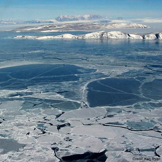
The data are approximately 800 km of airborne electromagnetic survey of coastal sea ice and sub-ice platelet layer (SIPL) thickness distributions in the western Ross Sea, Antarctica, from McMurdo Sound to Cape Adare. Data were collected between 8 and 13 November 2017, within 30 days of the maximum fast ice extent in this region. Approximately 700 km of the transect was over landfast sea ice that had been mechanically attached to the coast for at least 15 days. Most of the ice was first-year sea ice. Unsmoothed in-phase and quadrature components are presented at all locations. Data have been smoothed with an 100 point median filter, and in-phase and quadrature smoothed data are also presented at all locations. Beneath level ice it is possible to identify the thickness of an SIPL and a filter is described (Langhorne et al) to identify level ice. Level ice in-phase, quadrature and SIPL thickness, derived from these, are presented at locations of level ice. For rough ice, the in-phase component is considered the best measure of sea ice thickness. For level ice where there is the possibility of an SIPL, then the quadrature component is considered the best measure of ice thickness, along with SIPL thickness. All data are in meters.
-

The data set contains sea ice thickness (consolidated ice plus snow) of pack ice in the Western Ross Sea acquired by fixed wing aircraft (BT-67 C-GJKB) between McMurdo Sound (77.68 S / 165.52E) and near Cape Adare (72.01 S / 171.53 E). Two survey profiles are oriented South - North near parallel and about 100km off the Victoria Land coast, and two survey profiles are leading into Terra Nova Bay oriented in East –West direction at around 74.5 S and 75 S. The total length of the survey profiles is about 800 km. The Southern survey was flown from 9 November 2017 22:19 UTC to 10 November 2017 00:25 UTC beginning in McMurdo Sound and went for 300 km to the north, before turning west into Terra Nova Bay for another 100 km. The Northern survey was flown on 11 November 2017 from 1:21 UTC to 3:04 UTC from near the Adare Peninsula in a southerly direction for 215 km before turning southwest towards Cape Washington for another 140 km. The airborne electromagnetic induction (AEM) ice thickness sensor was towed by a Basler BT-67 aircraft sampling thickness every 6m along the flight track. The accuracy of the measured ice thickness is +/-0.1m over level ice. Ice thicknesses are biased up to 50% low for pressure ridges smaller than the signal footprint of about 45 m. Data was collected with the support of Antarctica New Zealand (event K066-1718-A; 25/10/2017-28/11/2017) for the New Zealand National Science Challenge Deep South (Targeted observation and process informed modelling of Antarctic sea ice, PI P. Langhorne). The purpose of data collection was to gain a basic understanding of sea ice thickness close to the areas of the Ross Sea, McMurdo, and Terra Nova Bay Polynyas.
-
Ocean–atmosphere–sea ice interactions are key to understanding the future of the Southern Ocean and the Antarctic continent. Regional coupled climate–sea ice–ocean models have been developed for several polar regions; however the conservation of heat and mass fluxes between coupled models is often overlooked due to computational difficulties. At regional scale, the non-conservation of water and energy can lead to model drift over multi-year model simulations. Here we present P-SKRIPS version 1, a new version of the SKRIPS coupled model setup for the Ross Sea region. Our development includes a full conservation of heat and mass fluxes transferred between the climate (PWRF) and sea ice–ocean (MITgcm) models. We examine open water, sea ice cover, and ice sheet interfaces. We show the evidence of the flux conservation in the results of a 1-month-long summer and 1-month-long winter test experiment. P-SKRIPS v.1 shows the implications of conserving heat flux over the Terra Nova Bay and Ross Sea polynyas in August 2016, eliminating the mismatch between total flux calculation in PWRF and MITgcm up to 922 W m−2. RELATED PUBLICATION: https://doi.org/10.5194/gmd-16-3355-2023 GET DATA: https://doi.org/10.5281/zenodo.7739059
-

Ocean–atmosphere–sea ice interactions are key to understanding the future of the Southern Ocean and the Antarctic continent. Regional coupled climate–sea ice–ocean models have been developed for several polar regions; however the conservation of heat and mass fluxes between coupled models is often overlooked due to computational difficulties. At regional scale, the non-conservation of water and energy can lead to model drift over multi-year model simulations. Here we present P-SKRIPS version 1, a new version of the SKRIPS coupled model setup for the Ross Sea region. Our development includes a full conservation of heat and mass fluxes transferred between the climate (PWRF) and sea ice–ocean (MITgcm) models. We examine open water, sea ice cover, and ice sheet interfaces. We show the evidence of the flux conservation in the results of a 1-month-long summer and 1-month-long winter test experiment. P-SKRIPS v.1 shows the implications of conserving heat flux over the Terra Nova Bay and Ross Sea polynyas in August 2016, eliminating the mismatch between total flux calculation in PWRF and MITgcm up to 922 W m−2. RELATED PUBLICATION: https://doi.org/10.5194/gmd-16-3355-2023 GET DATA: https://doi.org/10.5281/zenodo.7739062
-

In collaboration between Korea Polar Research Institute and NIWA, an oceanographic mooring was deployed close to the bottom depth near the Drygalski Ice Tongue (lat:-75.275700, lon:164.067300) on 9 March 2018 as a part of the ANA08C research cruise, and it was recovered on 3 January 2019. To monitor physical properties (Temperature, Salinity, Current) of deep water near the Drygalski Ice Tongue. GET DATA: https://kpdc.kopri.re.kr/search/9826749c-376a-4751-8812-702cec76c4c0
-

In collaboration between Korea Polar Research Institute and NIWA, an oceanographic mooring was deployed to the North of the Drygalski Ice Tongue (lat:-75.360767, lon:164.746467) on 9 February 2017 as a part of the ANA07C research cruise, and it was recovered on 5 March 2018. To monitor physical properties (Temperature, Salinity, Current) of ocean water in the north of the Drygalski Ice Tongue. GET DATA: https://kpdc.kopri.re.kr/search/c266365d-4846-4242-952b-75102a53110b
-

In collaboration between Korea Polar Research Institute LDEO and NIWA, an oceanographic mooring was deployed close to the bottom depth in the Drygalski Basin (lat:-75.010487, lon:165.555680) on 6 March 2018 as a part of the ANA08C research cruise, and it was recovered on 5 January 2019. To monitor physical properties (Temperature, Salinity, Current) of deep water in the Drygalski Basin. GET DATA: https://kpdc.kopri.re.kr/search/992862c1-84d0-46aa-97dd-e2dcfb12357e
-
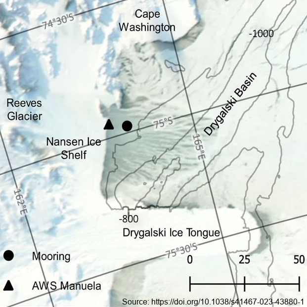
The mooring was deployed from February 2017 through February 2018 at 74.97° S, 163.96° E, approximately 7km east of the Nansen Ice Shelf in a region of TNB. The purpose of this study was to utilize data from a uniquely positioned and densely instrumented mooring to calculate HSSW production rates in TNB from continuous, in-situ observations. Moored instrumentation consisted of 7 SeaBird Electronics conductivity and temperature (SBE37-SM/SMP MicroCAT) sensors at depths of 47, 95, 119, 144, 168, 219, and 360 m and an upward-facing 600 kHz Nortek Acoustic Wave and Current (AWAC) profiler at 37 m depth, collecting both current velocity profiles in the upper ~35 m of the water column as well as Acoustic Surface Tracking (AST) measurements. Temperature and salinity measurements were validated against a shipboard conductivity-temperature-depth (CTD) cast performed upon deployment of the mooring. Temperature and salinity at 47 m and 95 m were additionally validated against a CTD cast performed upon recovery of the mooring. Full details of methods can be found in https://doi.org/10.1038/s41467-023-43880-1 GET DATA: ukm2103@columbia.edu
-

In collaboration between Korea Polar Research Institute and NIWA, an oceanographic mooring was deployed to the North of the Drygalski Ice Tongue (-75.360083, lon:164.748633) on 3 March 2018 as a part of the ANA08C research cruise, and it was recovered on 4 January 2019. To monitor physical properties (Temperature, Salinity, Current) of ocean water in the north of the Drygalski Ice Tongue. GET DATA: https://kpdc.kopri.re.kr/search/90416713-7e1f-4c4d-a0b6-46c8deeea43e
-

In collaboration between Korea Polar Research Institute and NIWA, an oceanographic mooring was deployed to the south of the Drygalski Ice Tongue (lat:-75.488417, lon:163.174350) on 12 February 2017 as a part of the ANA07C research cruise, and it was recovered on 7 March 2018. To monitor physical properties (Temperature, Salinity, Current) of ocean water in the south of the Drygalski Ice Tongue. GET DATA: https://kpdc.kopri.re.kr/search/9245184f-b187-4c1e-ad6f-32ed1f9493c8